Goldie
Overview
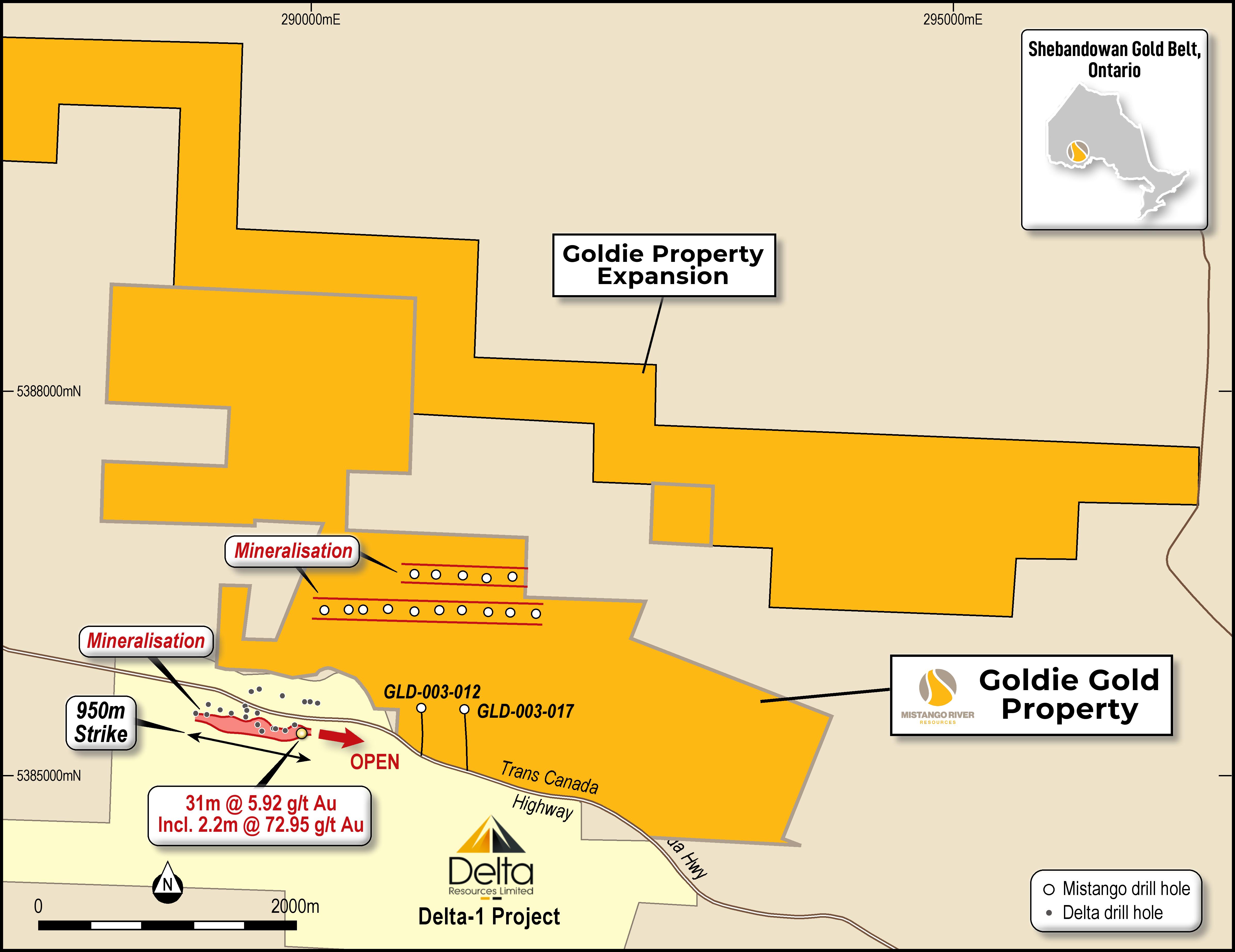
Goldie straddles the Trans-Canada highway, 50KM west of Thunder Bay and is accessed by forestry roads. Goldie is within the Shebandowan Greenstone Belt and covers a 89km of strike on the Shebandowan Structural Zone which also hosts Goldshore Resources Inc's (GSHR:TSXV) low-grade high-tonnage Moss Lake gold deposit, 50 km to the west. Goldie is also adjacent to Delta Resources Limited (DLTA:YSXV) Delta 1 Gold Property. Historical work on the property has demonstrated that significant gold mineralized zones exist within the property. More than 4,000 meters of diamond drilling was completed on various programs dating back to 2006 and covered a gold-bearing structure with over 2km of strike.

Current Drill Results
Mistango is pleased to announce that it has discovered a near-surface high-grade gold zone over 1 km in strike length at the Goldie Project. This drill program tested the northern border of a high-grade gold zone recently discovered by Delta Resources adjacent to Delta-1 Project. Mistango's Goldie drill program completed seventeen holes over 2,780 metres, combining RC and diamond drilling. All assays for the diamond drilling are still pending, with visible gold observed in one of the diamond drill holes.
Highlighted Assays from the RC Drilling:
-
GLD-002-006, 0.378 g/t Gold from 89 to 94 m
-
GLD-003-008, 2.02 g/t Gold from 153 to 167 m
-
GLD-003-011, .54 g/t Gold from 33 to 46 m
-
GLD-003-011, 16.6 g/t Gold from 70 to 71 m
-
GLD-003-013, .61 g/t Gold from 61 to 63 m
-
GLD-003-015, 1.13 g/t Gold from 48 to 54 m
-
GLD-003-016, .95 g/t Gold from 66 to 69 m
Previous Results
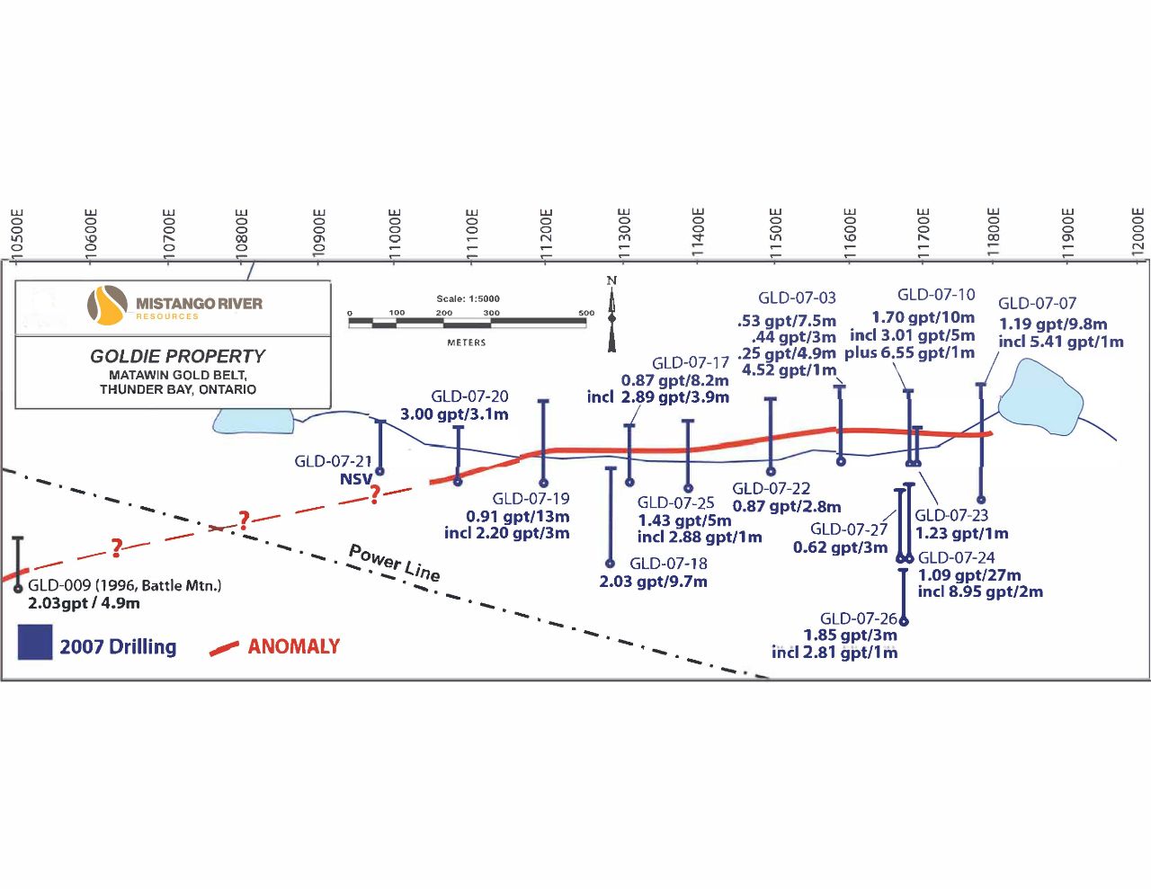
Initial drilling at Goldie in 2007 demonstrated a robust gold zone on the property. This non-outcropping, near-surface discovery extends across the property and appears to have hundreds of meters of strike based on IP data. Additionally, the depth potential is untested since all the drilling has only tested the property to approximately 120 metres of true vertical depth.
The anomalies and trends at this property are associated with historic diamond drill intercepts and surface gold showings located over a 3 km strike length of favourable geology.
The previous drilling near the anomaly had intersected many near-surface gold intercepts, such as drill hole GLD 07-10, which yielded 1.56 g/t Au over 11.1 meters and 1.91 g/t Au over 9.1 meters. Additionally, drill hole GLD07-24 intersected 8.95 g/t Au over 2m, 1.73 g/t Au over 14.5 meters and 1.68 g/t over 5.7 meters.
Geology
All sediments generally trend in an East-West direction and have a near vertical dip. These sediments are dominated by arkoses, quartzite, conglomerates and greywackes in that order of abundance, quite different from the sub-surface lithologies revealed by drilling. Very little of the intense shearing, brecciation and often pervasive alteration of these sediments is shown by any outcropping. Furthermore, the igneous rocks have a mundane appearance radically different from their drill core analogues. This discrepancy can be explained simply from the different locations of the drill holes relative to the exposed bedrock-virtually all of the drilling occurred in topographically lower areas.